Tuesday, March 30, 2010

60 Hikes Richmond 2.0 in stores now!


The second edition of 60 Hikes within 60 Miles: Richmond hit store shelves on March 15, 2010--just in time for the Spring hiking season. The completely updated guidebook features improved maps, more photos and new trails. New hikes include Virginia Capital Trail and High Bridge Trail State Park.

With new regional chapters, the revised guide makes it easier to plan a weekend hiking trip to the Northern Neck, Williamsburg, Charlottesville or one of several state parks and forests in Central Virginia.

You'll find the guide at Fountain Bookstore, Blue Ridge Mountain Sports, REI, Barnes & Noble and online at Amazon.com or Menasha Ridge Press.

Tuesday, May 1, 2007


Don't take my word for it


Lee Graves in the Richmond Times Dispatch:
Finding forests to hike now requires a bit of a drive, which is why I'm glad to have resources such as 60 Hikes Within 60 Miles: Richmond ... a fresh addition to the 60-60 series from Menasha Ridge Press.

Style Weekly:
Whether you’re looking for a hardcore adventure or a picnic with the kids, local writer Nathan Lott’s new book, 60 Hikes Within 60 Miles: Richmond ($16.95, Menasha Press), offers an exhaustive guide to finding the perfect outdoor experience for you.


Fredericksburg Freelance-Star:

These state and regional hiking guidebooks just get better and better. And Lott, a Richmond hiker and writer, has used all the best, most helpful features and graphic assists in this new book.
Although this is a Richmond-centered guide, there are just enough trails in our part of Virginia to make it worth buying.

Richmond.com:
In addition to providing key information such as length, difficulty, hiking time, configuration and scenery, Lott also gives readers information on history, ecology and natural sciences in each of his three- to four-page hike descriptions.

OutRiderBooks.com:
Residents of Richmond, Petersburg, Williamsburg, or Fredericksburg -- and visitors to the area -- will find plenty of good reasons to strap on some hiking boots and get outdoors in this helpful guide.

Buildings and Bridges


One might not expect to find a lot of architectural history in a hiking guidebook, but whenever applicable I mention important or interesting structures in 60 Hikes within 60 Miles: Richmond. Not surprisingly, given the area's long past, one often has ocassion to encounter a curious, if crumbling, building in the Virginia countryside. Below are some that stand out, in varying states of repair.


Having escaped damage during the Civil War, Fluvanna County Courthouse in Palmyra remains unadorned and uncompromised by additions. Its Acropolis-like hilltop location recalls that of Virginia's Thomas Jefferson-designed capitol. (Visit the town now, before the Charlottesville suburbs swallow it.)


Not far from Palmyra is the Federal-style Haden House (above), which may yet be revovated. Attached by a covered walk, the kitchen, with its large stone oven, is a little the worse for wear but fortunately never caught fire.


George Washington's boyhood home was burned to the ground, but that didn't stop Rockefeller and other admirers from erecting this Coloinial-style mansion with a clapboard kitchen as a memorial. The foreground of this shot shows the location of the Washingtons' more modest home, which is outlined in crushed oyster shells.


St. Mary's Whitechapel on the Northern Neck was first built in the 17th century. This building is an early 18th-century replacement, but still a well-preserved example of Colonial ecclesiastical architecture. Note the entrance on the wider dimension and the absence of a steeple.


Ramshackle clapboard churches like this one are a common, often charming site along rural Virginia roads.


The weathered wooden pumphouse(?) in the upper half of Charlottesville Reservoir stands on a pediment of rusticated stones, which is submerged at high water levels. At lower levels, the revealed pedestal appears comically surreal, especially because nothing remains of the footbridge that presumably linked the pumphouse to the earthen dam (just out of sight in this image).


This 1890 home now in Zoar State Forest replaced an earlier structure erected by Robert Pollard in the 1790s. Because he found the nearby crossroads of Ayletts a den of iniquity, Pollard named his home Mount Zoar in reference to the Biblical city where Lot took refuge after fleeing Gommorah. Perhaps ironically, flames engulfed the original manse in 1885.


When built in the 1930s, this Albermarle barn was an agricultural showplace. It had a milking parlor and accomodated a variety of livestock. The owner was an agricultural extension agent; an African American, he was the first agent assigned to serve black farmers in the area.


Richmond's Boulevard Bridge opened in roaring 1925 for the convenience of the city's growing south-of-the-river suburbs. As a sort of linguistic memory, many people still refer to it as the Nickel Bridge (the modern toll is a quarter).


This New Deal-era swinging bridge over the Willis River in Cumberland State Forest was perhaps by the CCC but more likely by the WPA. Its steel cables and log beams remain sturdy, though the floorboards inspire some trepidation.

Visual Lagniappe from 60 HIKES RICHMOND


It's been months since I posted to this blog, having determined to put it to rest in order to tackle a new job and wrap-up a major writing project, the guidebook 60 Hikes within 60 Miles: Richmond. Now that the latter has gone to press, it occurs to me that this site (thanks to Google) remains an asset for more than posterity's sake. Why not use this webpage to post photos, and perhaps annectdotes, omitted from the book because of space limitations? Among the images below are several I first posted as a series during the course of my research.


All the photos below were taken within 60 linear miles of Richmond, Virginia, seen here from the footbridge that accesses Belle Isle.


A fallen tree rests in Morris Creek Marsh.


A Cypress Stand on the Chickahominy River a few miles away.


A great blue heron standing on a submerged tree stump at Newport News Park.


A 400-year-old wheat field at Chippokes Plantation.


The beach just downhill along the James River.


A boulder garden in the James upriver.


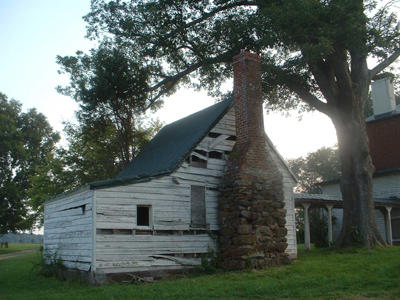
A pair of old barns in Amelia County. The neighboring farmhouse has been abandoned.


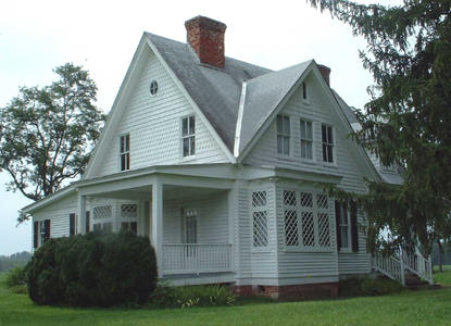
A different dilapidated farmhouse, this one along Walnut Creek in Albemarle.


The mist and lighting in this photo of Walnut Creek Reservoir recall a naturalist painting.


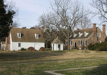
The Smoot House at Caledon State Park is almost a century old. John Alexander, for whom Alexandria was named, settled the area in 1659.


Big Meadows Creek threads through a wide marsh before it empties into the Potomac.


Just upriver, pale dolomite cliffs tower over the Potomac.


There are no hogs on Hog Island today. There are foxes.


This Civil War canon still guards Spotsylvania Court House Battlefield.


Small crabs thrive in this marsh bordering the York River.


These zebra swallowtail butterflies were shot on a bluff above the York.


The wrought-iron fence of a small, overgrown family cemetery in Powhatan County.


Beaver Lake, at Pocahontas State Park, was not built by beavers but men under 25 earning $30 a month as members of the CCC. $25 dollars were sent home to their families.

This cedar bog stands on the periphery of Holliday Lake.


A turbid Holliday Creek seen from atop the lake's dam.